Synopsis (tl;dr version)
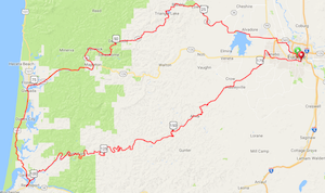
This will be a fast route for many riders, not particularly hard as 300k brevets go, but the second half is definitely harder than the first half. Consider bringing a third bottle if the day is warm, just for the section from Reedsport to Oxbow Summit. Drink up in Reedsport and fill all the bottles, and top up again at Smith River Store (about 20 miles in from Reedsport).
Edit June 21: It is going to be hot! I very strongly recommend carryng extra water from Reedsport, even if it's just an extra half-liter in a jersey pocket.
Pre-ride
Michal Young pre-rode the route June 17, 2017, starting 5am. I rode based on the cue sheet alone without loading the route on GPS. These notes are sequential along the route.
McDonalds has only drive-through at 5am, which is not useful for our purposes. Fortunately just half a block away the Burrito Boy is open and serving food. I did not ask to use the restroom, but I presume they should have one.
[Mile 0] My cues for getting out to the bike path, taken from Google and Ride With GPS, were unusable. Although the path is tantalizingly close to the starting point, the railroad makes it difficult to get directly to. On the other hand, there is almost no traffic at 5am. I will set a simpler path on streets to Skinner Butte Park, where it is simple to get on the path. EDIT: Fixed, we will start east on Broadway and make one right onto High Street. This removed several turns and did not alter the distance. The River Bank Path is very pleasant at 5am ... this will be a nice way to get started.
[Mile 4] We transition off the path to streets that are pretty busy later in the morning, but they are fine that early. The crossing of Hwy 99 at mile 7.4 is protected by a traffic light, and it was triggered by my (steel) bike! On the left, just before that crossing, is a gas station mini-market open early (probably 24 hours) with restrooms and a variety of convenience store foods.
[Mile 19.6] Transition to Hwy 36. I have been informed that next weekend is the “52 mile yard sale” all the way from Junction City to Mapleton. This is apparently a big deal, and will bring the heaviest traffic of the year to the highway. (Can I pick ride dates or what?) However, we will be going through before the worst of it. I was to Deadwood (mile 48.5) before 9am, which is when (according to the cashier at Deadwood Country Market) we can expect to start seeing significant traffic. I'm not a particularly fast rider, so I expect many of you will be close to Mapleton by then.
[Mile 35.5] Triangle Lake: The little grocery store on the right will be open by 7. (Low Pass Market, at mile 26.7, opens at 8 and will almost certainly be closed when you pass.) At this point you've already summitted the coast range, and a nice decent begins. Watch for pocks in the pavement from falling rocks. Lake Creek on your left is very pretty, but hard to appreciate if you are zooming past.
[Mile 48.5] Deadwood (control). The store opens at 8. Offerings are pretty slim ... ice cream bars, sodas, coffee, chips. There will be an information control questions for those who arrive before it opens at 8, and you may also answer the information control question if you prefer to ride on to Mapleton or Florence for resupply. Deadwood Country Market does have a restroom.
[Mile 61.7] Mapleton. Several places to eat on the left after the merge with Hwy 128. I did not stop on this ride, but in the past I have often had coffee and pastry at Caffeination Station, and I have had a hearty lunch at Alpha Bit cafe. On the other hand, at this point you're so close to Florence that I imagine most riders will prefer to just grind out that last 10 miles until the control.
[Mile 76.1] Florence (control). Both lanes of road turn left, but you may want the left lane (turn only) so that you can follow it with a left just after the corner to the Safeway. I skipped the Safeway thinking that there was another grocery on the right, but I must have confused it with another town. The Safeway in Florence is considerably larger than the Safeway in Reedsport, so you might consider resupplying here. I instead had a soda at Nature's Corner Cafe & Market, shortly before the bridge. In the worst case, if you miss the markets in Florence, there are small convenience stores a few miles south, and I will accept those also as the Florence control.
The bridge at the south end is under construction, and not really pleasant, but automobiles were polite and patient as I crossed.
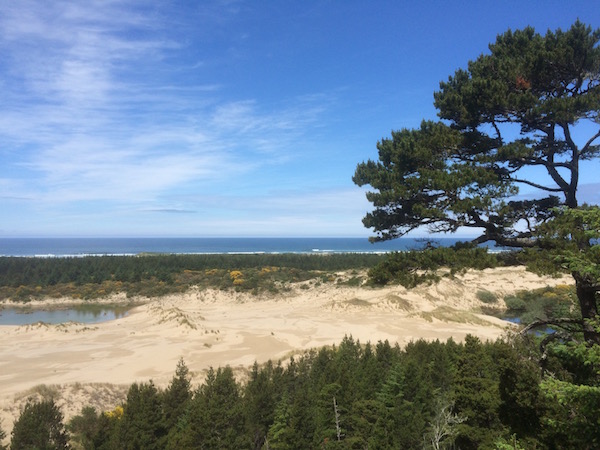
The first few miles south from Florence are only so-so, but soon you'll be riding through coastal forest and along some nice coastal lakes. The road runs far enough inland that there are few glimpses of the ocean, but there is one really nice viewpoint: The National Dunes Day Use area at approximately mile 86.5. Turn right at the sign, and it is perhaps 1/8 mile in to the parking lot. There is a covered area for looking out over the dunes to the ocean, roughly 1/2 mile away. No chance to dip your wheels, but the view is gorgeous.
[Mile 98] Reedsport (control). Two bridges into Reedsport ... again I found auto traffic polite and patient. I really wanted soup and/or a sandwich, and expected to find them at the Safeway. No such luck ... this might be the smallest Safeway I've ever been in. Potato salad came only in family size. There is a restroom, toward the back (look for a label on the double doors). In retrospect I should probably have just left the Safeway and tried either the McKays Market (just north on the other side of the street) or a fast food place. There is a Subway in the same cluster as the Safeway, and a McDonalds and Dairy Queen also close by.
Rehydrate and top your bottles in Reedsport. The next segment is long and fairly remote, with just one small market about 20 miles in. If you carry a third bottle, fill it in Reedsport.
I would also appreciate a text letting me know when you are in Reedsport, so that I can make a rough guess as to when to expect you at the Oxbow summit. If you decide to abandon (I hope not!) then a text message is especially important so that we don't worry about you being stranded somewhere in the next remote section.
[Miles 99-150] You cross the bridge again coming north out of Reedsport, then exit right onto Lower Smith River Road before coming to the second bridge. The first 15 or so miles are nice pavement, and on a warm day you will have a tailwind. You'll pass a couple small parks with vault toilets. At about mile 114.5 you will reach Smith River Store. It is open but quite small; you can get a soda and chips but don't expect much else. Unless you want a beer, because it's also a pub.
This section is really the highlight of the ride. Parts are pastoral, parts are forest, and almost all of it is gorgeous until you reach some unsightly clear-cuts as you approach the summit. Most of the climbing is gentle, again until you near the summit. Pavement quality varies; the chip seal just beyond Smith River Store is pretty rough.
You will lose cell phone service sometime between Reedsport and the Smith River Store, so you might as well put your phone in airplane mode. I forgot to do it before leaving Reedsport, remembered at Smith River Store, and noticed that my phone was down to 30% battery because it had wasted a lot trying to make connections to the fading cell signal.
The climbing gets hard just a few miles from the Oxbow summit, but the climbing doesn't last long. You'll be at the control before you know it.
[Mile 149] We will have a staffed control for you at Oxbow Summit. We'll have water and instant soup — cup-o-noodles for most riders and one or two portions of a vegan lentil soup for our vegetarian riders. (I am pretty sure Keith is vegan ... anyone else have dietary restrictions?) We'll also have water to top your bottles. I don't think you'll be in the mood for bars and sweet stuff, but we'll have a bit on hand in case. If there is something else that you think you'll really, really want 150 miles in, with one more hard climb ahead, let me know.
I got one bar on Verizon at the summit, and was able to send a text message.
[Miles 149-166] There is a swift curvey descent from the summit. Use some care, because there are some big drops from the edge on those hairpin turns. Then there is a bit of flat or rolling terrain as you proceed through Alma, an abandoned prison, and on toward the Wolf Creek turn (mile 156.8). Harder climbing starts immediately after the turn and continues for about 3 miles. You will have cellular telephone service again at the summit of Wolf Creek.
The descent from Wolf Creek summit is a delight ... steep enough to work up some real speed, with swoopy curves that won't make you ride your brakes overly much. At about mile 161.5 the first descent ends, and there is a very gentle climb to a second, minor summit at about mile 166, followed by one more swoopy descent.
Just as that beautiful descent finishes and the road flattens out, you reach the turn onto Territorial Road.
[Mile 168.5-177] DS Market in Crow is about 1 mile off course; just continue Territorial without turning onto Crow Road. Closes at 8. But if you stay on course, there is a gas station with a Jacksons at mile 177, where Crow Road crosses Hwy 127 and becomes Greenhill Road. I really needed it, as my water bottles were empty despite carrying a folding extra bottle that refilled one of my regular bottles and half of the other, and I would have drunk more if I had more. (You'll get topped up at Oxbow, so you won't need as much as I did.) The soda fountain in the Jacksons will dispense water (the lever is under the Gatorade spout), so you can buy some small thing and refill your bottles free if you want. I like to fill one bottle with water and buy a soda with lots of ice to pour into the other.
[Mile 177-187] Technically you are on Greenhill Road before you reach the intersection at Mile 177, but you won't notice it unless you are following a GPS that announces it. The traffic light where Greenhill crosses Hwy 127 will not sense a bicycle, so you may need to use the cross-walk signal. The Jacksons is on your right on the north side of the intersection.
You ride about a mile north on Greenhill and take a right into Meadowlark Prairie Park, the western terminus of Fern Ridge Path. The path parallels Greenhill for about a third of a mile, then turns right just where Greenhill Road meets Royal Ave. If you missed the turn into Meadowlark Park, there is another entry to the path just before the intersection.
There is an information control at the turn, actually at the bench which is just after the turn and a small bridge. It will be simple, and if you have any difficulty with it just take a picture of the area to prove you didn't short-cut the route by taking Hwy 127 in, which of course you didn't because that would be unpleasant and unsafe.
And then ... just path, path, path into Eugene. There are a few dog-legs where you need to be on a street for a very short connection between segments of path, but those will be obvious. There is one confusing Y where you could go left to Roosevelt or right to Eugene Downtown (mile 179.1); go right. A few times the path splits to give you the choice of going under a bridge or crossing at street level, and unless we have an unexpected deluge of rain between now and Saturday you should choose the underpasses.
The path finally ends just before Jefferson Ave. The path turns hard right, then you exit it to dog-leg over the 15th Street and right onto the street (you'll see it's the only way to transition onto a street continuing east). 15th street is a designated bicycle route with sharrows. You take it all the way to Alder street, the west edge of the University of Oregon, and there turn right onto a two-way bicycle way on the left side of the street. The first traffic light you come to is 18th, which has a dedicated light for cyclists and a good sensor to trigger it. Turn left on 18th, over a little hump and down to Agate, turn right and in one block you'll see McMenamins on your right.
A volunteer will be inside McMenamins to sign your card and congratulate you. We'll try to also have a few bike locks available so that you can leave your bicycle on the bike rack. McMenamins is a branch of the same chain that has a number of brew-pubs and interesting inns around Oregon. The 19th Street McMenamins Cafe is a smaller outpost, with no brewing on-site, but it offers the usual McMenamins menu including Terminator Stout, cajun tots, Captain Nemo burger, etc.
Other logistics
Parking: The start and the end are approximately a mile apart. You might want to park between them, but closer to the end, because you'll be a lot more tired then. Edit: The lot I initially recommended, behind the Law School, has been replaced by new student dorms. However, there is a section of 15th street on the west side of Agate that is free on Saturdays. Signs say overnight parking is prohibited, and times before 5am and after midnight are considered overnight, but I doubt they are checked after 4am or before 1am.
Lodging: Phoenix Inn Suites is near the start. New Oregon Motel is nearer the end of the ride. There are numerous smaller hotels near the start point.
Beer: If you live in Eugene, you don't need my advice on this. If you are visting and have time for some local beer and good food, I highly recommend Falling Sky Brewing House & Gastropub, 1334 Oak Alley. Food prices are on the high side, but worth it. The Bier Stein at 1591 Willamette Street has the widest selection of microbrews in town, and possibly in the galaxy. Ninkasi is probably the most famous beer out of Eugene, with a pleasant outdoor dining area.
Main event page (description, registration, etc.)
